
Student inventor and ‘tinkerer’ facilitates drone research at UWGB
With a combination of his own inventiveness and ingenuity, and support from UW‑Green Bay faculty, sophomore Cody Becker is using high-impact experiences to uniquely tackle a local problem (invasive plants) while preparing himself for the evolving demands of the contemporary workplace.

Cody Becker
UW‑Green Bay sophomore Cody Becker is a self-proclaimed tinkerer and inventor with an entrepreneurial spirit. At 15, he modified a bicycle to make it motorized. By the time his was 17, he built a generator that splits water into its component gases, hydrogen and oxygen.
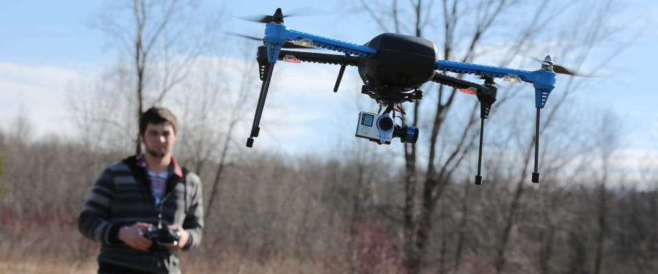
It should come as no surprise then, that when called on, the UW‑Green Bay sophomore from Sheboygan, Wis. was able to research and modify a drone to help UWGB Prof. Bob Howe and the Cofrin Center for Biodiversity with vegetation and invasive mapping of the University’s natural areas.
Becker is an Environmental Science and Geoscience major (with a minor in Physics) at UW‑Green Bay. He is also pursuing an Environmental Science and Policy (ES&P) integrated master’s degree.
His college accomplishments are already earning him praise and some financial acclaim. He is a recipient of the Natural and Applied Science Chad Moritz and Beth Meyerand Annual scholarship, and was selected to show his research, “Aerial Surveying and Vegetation Mapping Using Drone Technology at the Point au Sable Nature Reserve” at the 2016 Posters in Rotunda session at the Capital in spring.
“Cody impressed me right away,” said Howe, who met Cody just a little over a year ago when he interviewed for a summer research opportunity at the Cofrin Center for Biodiversity. “I was intrigued by his interests and experience in applications of new technology, such as the use of remote controlled drones for scientific research. He has exceeded even our initially high expectations.”
Although he has worked on a variety of projects, including mammal
surveying and vegetation mapping, it’s the drone research at Point au Sable that others seem to take an immediate interest in.
Point au Sable is a well-mapped natural area owned by the University just a few miles from campus. Becker and his team evaluated the area by using a Quadcopter drone and a GoPro camera to take high definition wide-angled videos. The drone is used to fly in a grid pattern to obtain high resolution video of Point au Sable. (See sidebar for details.)
Aerial surveying is an important tool in identifying invasive species, in particular the aggressive grass Phragmites australis, because the low altitude drone video allows scientists and Geographic Information System (GIS) specialists to visually identify areas requiring treatment and management. This means less time spent identifying and mapping the invasive species and more time directly managing them.
Becker also assisted the University’s Risk Management Committee by submitting his written “Drone Code of Ethics,” which provides rules for all new drone pilots to follow.
Becker said others tend to recognize and comment on his ability to both engineer, and also communicate — a rare right-brain, left-brain combination.
“To get to the point of obtaining the drone, I would have to explain the technical aspects of the drone to those who are considering the environmental side of the issue and how we could best get the information we needed.”
Becker transferred to UWGB from UW-Milwaukee where he started out in a mechanical engineering program. In a robotics lab at UWM he studied, designed and built a kite-based multispectral imaging system that could rapidly assess the growth of near-shore algae in Lake Michigan and a large radio-controlled pontoon boat for plankton sampling
“I decided that mechanical engineering would be a great hobby, but not a great career for me.
I was familiar with UW‑Green Bay because of prior visits. I’m an outdoor-type person and the campus setting is a great fit for me.
I explored my first semester here for research opportunities and ended up in the Cofrin Center for Biodiversity. UWGB Professors Steve Meyer and Bob Howe and others have been incredible to work with.”
Becker also worked on other projects — with teams of student researchers studying mammal populations at the Wabikon Forest Dynamics Plot in the Nicolet National Forest in northern
Wisconsin; helping with vegetation management of university-owned natural areas in Lower Green Bay and participating in a field inventory of remnant natural habitats in the Lower Green Bay and Fox River Area of Concern.
In summer of 2016, Becker will work for a company helping with GIS mapping, but he will be back to work with the Cofrin Center for Biodiversity next fall, and hopefully until he graduates (first with his undergraduate in May of 2018 and as a ES&P graduate in May 2019). He and his faculty members have their sites on new technologies and modifications that can aid in further research such as integrating thermal imaging or infrared technology into the drone research.
Drone Video: From Collection to Desktop
During the drone flight, the onboard Pixhawk flight controller automatically creates flight logs which store all onboard sensor information. This information includes altitude, pitch, yaw, velocity, battery health and many other sensor data. The altitude at which the video was taken varies from 50 to 100 meters. The GoPro has a 170 degree wide angle, which allows a large field of view to be seen in the video. However, the nature of the wide-angled lens creates a fish-eyed distortion. After each flight, the 1080p video is post-processed. GoPro Studio Software is used to remove the fish-eyed effect from the video and to extract still images from the video and Windows Movie Maker is used to edit and create publishable videos for YouTube.